The ride description is here: http://www.seattlerandonneur.org/rides/ride_archive/300km/300km_2a_2003Desc.html.
Assorted nuts: not sure why I was doing this ride; had done a ride sponsored by SIR in March, and had barely finished in the allotted time of 13 hours (
something like 30 minutes to spare); due to this slow time, I abandoned the thought of completing the 200, 300, 400, 600km series in the spring. This ride in July served as part of a fallback option for completing the series later in the year. Such a series is a qualifier for some interesting rides:
Paris-Brest-Paris (also see
here), Boston-Montreal-Boston and the
Rocky Mountain 1200.
The Rocky Mountain 1200 is an interesting stretch goal; fantastic scenery, a familiar-yet-foreign land, and a really long bike ride. Figured I’d investigate the series this year; and if I completed it, I’d qualify the RM1200. It seems that a typical time for a 200k is about 10hours, and 300k about 15hours. I was going for that time. That’d mean being finished by 9pm. I’d worked out that a 14mph average while riding, combined with about 5 minutes of rest per hour, would do the trick. This all goes under the heading "Best Laid Plans".
It’s less than a two hour drive to Ellensburg. Checked into the hotel; for some reason I felt compelled to schlep the bike in by the back way. Next I drove the first part of the route. The route out of town was very straightforward. It would be the same route back into town.Looking at the summaries of the times for the first 4 SIR rides this season; a 10 hour time for a 200k is “typical”, and a 15 hour time for a 300k is also typical. I’m impressed that the approximate relation of 5 hours=100k holds up at 400k also.
Leg 0:Got up, applied sunscreen and went out for breakfast. Had breakfast at the truck stop by the interstate; extremely greasy (note: I've never gone back). I was the only customer. Back to the hotel to change into riding garb and bike the less-than 1 mile over to the Super 8. Met the ride organizers Terry and Erin (assumed spelling). Chatted briefly. They seemed kind of wiped; they’d ridden the 300k on July 4th. Terry described the wind, and that there was one other rider for today’s ride. Jeff. A couple of gentlemen working through the weekend 600k showed up and took off after some conversation. They’d had about 1.5 hours of sleep, and had 200k to go today. Jeff and I took off; he’d cased the route as well. We got out of town together quickly. Note: Jeff has a write-up of this ride as well. His write-up is a lot funnier than this one. Practice Practice Practice.
Leg 1: From the hotel w/ Jeff until part-way up Blewett pass.
Jeff stopped for water, I pressed on and up; the Camelback is great for long rides. A lot of wind; all the time. Altitude gain. Pilot error in the use of the HRM. Jeff and I traded pulls. The weather changed completely after the descent to the intersection of 97 and 970; cool (low 50s) and calm. Coincidence of the ride: Jeff and I were born in the same hospital in
Tulsa. Didn’t see him again till near the end of the ride (around mile 170; as he was heading into Cle Elum and I was going the other way). Jeff’s going to ride the Paris Brest Paris ride this year; so for him, this ride served as a tune-up. Talked about the kids and where we’d lived.
Leg 2: Up Blewett pass.
Just pedaled. It was slow; but, very early in the game. Lots of sweating. The pass isn’t exceptionally steep; but, had to work pretty hard to get up it in a reasonable time. Near the top; Kline and Brenda drove up to drop off Kline. Brenda said some encouraging words. They were staying at a campground at Ingalls Creek. Kline went up the last mile or two; then we blasted down the other side. The spirit of the Randonneuring game is that I can’t use outside assistance. We took that as no drafting (that is, I couldn’t draft Kline). I confess to taking a piece of licorice (red). The company was very welcome.
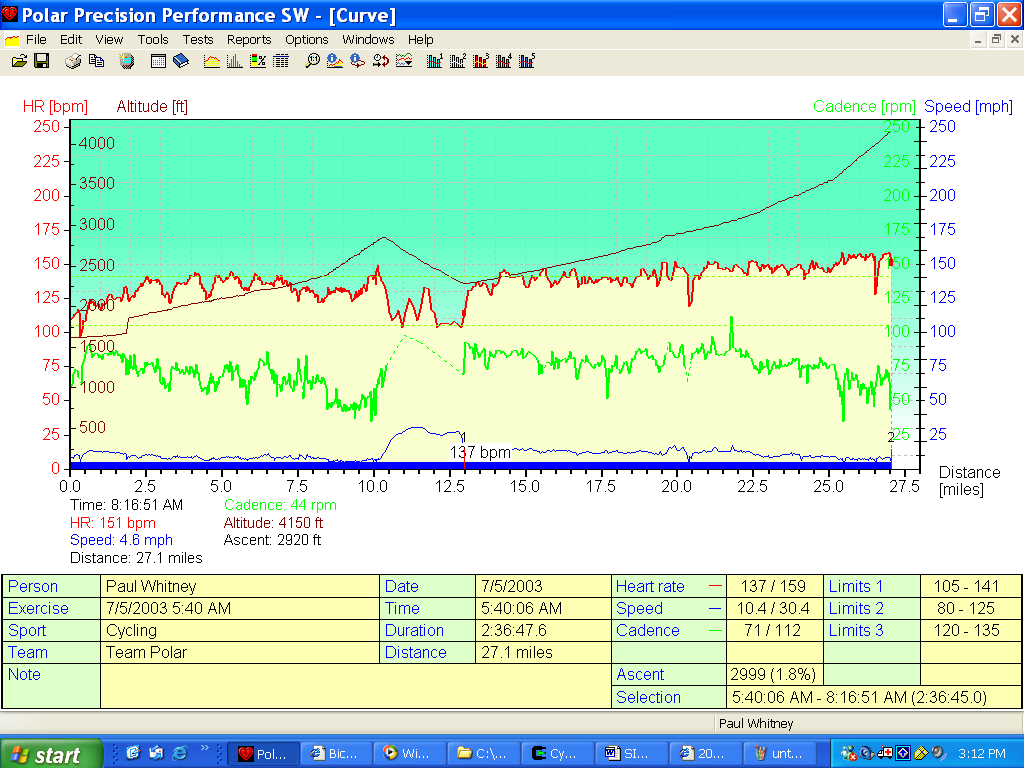
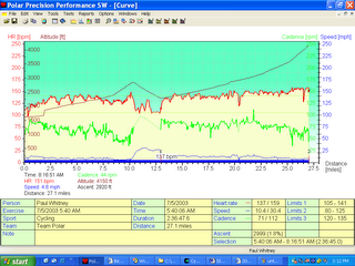 Figure 1: First leg. The first part is not accurate due to significant “pilot error”. It’s missing about an hour and about 7 miles. It was windy. The second is reasonably accurate. The brown line (altitude) goes up to the top of Blewett pass. The altitude numbers are almost accurate. The pass is about 4100 feet high.
Leg 3: Blewett pass into
Cashmere.
It was just plain fast. I felt I had a lot of time to make up from the crawling done against the wind and uphill (sometimes together). Started down fast, as there wasn’t a lot of shoulder at the top; and the less time spent on the road the safer. Pressed fairly hard. Talked some with Kline; but, basically was just pushing. Went by the campground that Kline, Brenda and the boys were staying at. We kept on. Hit highway 2 and turned right towards Cashmere. Went along the Wenatchee river; very nice. This was continuing downhill so our speed remained high. Had to find the Red Apple market at Cashmere and get someone there to sign my card. The card, always part of a Brevet, is used as a record that the ride was completed in the time-period. I
almost forgot about the card more than once, as I was more interested in the ride. It turns out that the Red Apple changed names. Went into the grocery store, I asked whether it used to be the Red Apple and the extremely young person behind the counter went back far into her memory to say “Yeah, I think so”. Good enough for me. Bought some water and a sandwich, then Kline and I went vagrant outside the store and ate our food while customers filed in and out. Filled the various water bottles and headed out toward Leavenworth. We saw Jeff as we headed out. I pointed him at the ex-Red Apple.
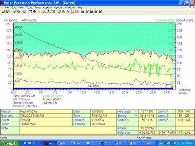
Figure 2: From the top of Blewett pass down into Cashmere. I had to work hard for the speed.
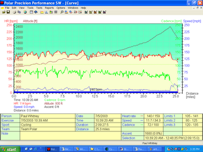 Figure 3: Cashmere to Plain. I’ve mentioned to Polar that another piece of data to capture is the wind. This whole @#$()*( leg was against the wind. The elevation gain is kind of like 1.5 Webber canyon rides.
Leg 4: Cashmere to Plain.
It was more uphill-and-against-the-wind. It wasn’t going to be pretty, scenery-wise, till we got towards Leavenworth. So, we went up and out. Backtracked for awhile and then got beyond US97. Ducked into Leavenworth and headed North up the Chumstick (<- not a pretty name) Hwy. More uphill-and-against-the-wind. #$(*()*. I was hoping that the trees would block the wind. They probably would in the forest, but not on the road. We eventually had to climb a minor pass. Kline pointed up where the road was going. I said something fatalistic and kept on pedaling. Eventually got a little further, looked up again and said “I guess I can do that”. Did it. Headed down. It was a rapid, curvy descent. The tar used to cover the cracks in the road was kind of slidy, so we both avoided it. Had to hit the brakes pretty hard around one bend and then into Plain. Got the traditional gallon-of-water and a Frappacino (one of those cold, bottled things). Kind of a gastro-intestinal gamble; but, I’m a coffaholic and went for it. It was good. Also had some peanuts; mostly for the salt. We sat; reloaded the water carrying devices, and continued.
Leg 5: Plain to Ingalls Creek.
Ran into Terry and Erin. Kline was kindly and properly paranoid about not even looking like he was assisting me, much less actually assisting me. They mistook him for Jeff. An easier run. Very pretty as we went down into Leavenworth. Had to blast over a couple of narrow bridges. Had a mishap; nearly a crash. I hit a rumble strip; didn’t even see it coming, and darted to the left. Kline had to hit the brakes fast to avoid me. Kline mentioned Prey’s fruit stand again. It’s a recommended place to stop for apples. We’d both each bought pumpkins there at various times. Back up hwy 97. Slowish. Went by a place where someone does the chainsaw carving of logs. I decided against picking one up as a souvenir. Stopped at the convenience store across from the campground. Kline had his left shoe’s cleat stuck in the pedal. I went into the store alone. Got a V-8. Some water bottles. Reloaded. Figured I needed the salt. I think it helped greatly. Said goodbye and headed on up.
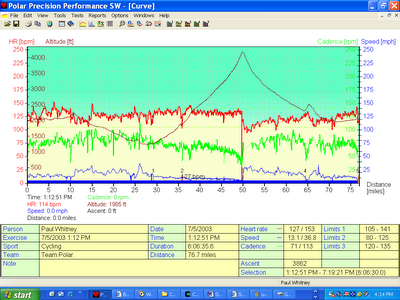 Figure 4: Plain to Cle Elum. The big peak is Blewett pass. There was a lot of work in there. The scenery on the Cle Elum side of the pass seemed to agree with me even better than the fine scenery on the other side.
Leg 6: Ingalls Creek to the Summit of Blewett Pass.
Ouch Ouch Ouch. Gave myself permission to arrive there by 6 (would have preferred earlier). Tried to have a gel every 30 minutes, stay hydrated and keep pedaling. Stopped part-way up for a nature break. Good to get off the bike. Stuff was numb. Resumed. Had to ride on a gravely shoulder about the last mile up. Hit the top around 5:55. Stopped. Dug out the cell phone to call home. Probably didn’t sound too good. Chatted and signed off. So, I figured that I’d gone about 200k, and had done so in 12hours. That sucked; same time as the 200km. Months of training and no basic improvement measured; my body had learned nothing. And, at that speed, I’d be done in about 6 hours. Midnight. That also sucked. Ate a bar. Realized I was hungry, so I ate another. Drank some and headed off down the pass.
Leg 7: Blewett Pass to Cle-Elum.
It was good to finally have one of gravity and the wind on my side for a change. Made good time at a relaxing heart rate. Just pedaled. Sang some (still need to learn more songs). And arrived at the potential bail-out point. I’d been thinking of heading straight to Ellensburg, essentially taking a DNF (Did Not Finish), getting home in the light while still getting a good long ride in. One way to deice would be to spit in the palm of one hand, hit the spit with the other, and depending on which way the majority of the saliva went, I’d chose my direction. But, it was kind of windy so I figured that wouldn’t work. I didn’t want to toss a coin; since that would mean stopping, dredging one out etc. So, when I got to the juncture, I looked UP at the Ellensburg option and up at the Cle Elum option, and decided that less climbing was good. Even better, a little up the highway they claimed about 12 miles to Cle Elum. That clinched it. It was against the wind; but, again I pressed on. The climb was small. About 6 miles later I stopped to eat again. Still trying to pound the gels regularly. Continued on into town. A couple of miles later I saw where I’d eventually by going to Ellensburg and smiled. I’d have the wind all the way back. Encouraged, I drove hard to the Safeway at a whopping 10 mph (against the wind). Pushed on into Cle Elum, looking for the Safeway. At the end of town there was a small hill (kind of
like Carmichael hill). The Safeway was up there. So, up it is. Got there. I was looking to get the card signed, have a gel, get some end-of-the-ride power-aid (expensive, but, palatable. Figured I needed to drink) and another V-8 (salt is good). Grocery stores are big; I gave up on my detailed shopping list and settled for another Frapacinno. It was about 8pm, sunset was at 9pm. So, I dorked up: put on the reflective vest and ankle bands. Turned on the lights and
booked out of town at 8:10.
Leg 8: Cle Elum to Ellensburg.
It was fast. I had the wind. It tended to be downhill. It was fast and I felt good to be going fast. While I’d had the goal of a 9pm finish, and the then the dark thought of a
midnight finish, I had enough speed and push to go for a 9-something finish. So I went back through town. Hit a red light and some green lights. And I was on out of town. Waved to Jeff as I turned off towards Ellensburg and he headed towards Cle Elum. Then the route moved onto a lightly trafficked highway along the river. It was great. Good views of the river. Great speed! The pounding-down-of-the-gels seems to have paid off. Saw another bicyclist heading the other way. Saw a semi-truck parked on one side of the road and an SUV on the other. And maybe saw a handful of cars. And there was plenty of river flowing by. Some birds. I had no actual power up the hills. It’s an odd feeling that I often get at the end of long rides; enough juice to keep going in the flats, but, nothing for the hills. Thankfully, the uphill stretches were never long. Got into town; had the route down thanks to the driving practice. Got to the Super-8, knocked on the door and turned in the card. The time was
9:35. Much better than I’d thought I’d achieve while at the top of Blewett.
Post ride: Got cleaned up. Watched the Tour de France prologue rerun. Gold Bless OLN. Lance looked un-skinny; not a good sign for the mountains. I had some numbness still; never had been that bad before. Showered. Went to dinner. Stomach was a little off. Had most of a chicken sandwich and, of course, all the fries. Ice tea and some tomato juice. Back to the room and to sleep. Awake at 3-something in the morning for no particular reason. Some weird move on HBO. A professional killer (ex-FBI). Lots of double-crosses. I sure hope I didn’t see the whole movie. The tour started at 6:00am. I started packing, loading the car during commercials. Snagged a continental breakfast; started home around 8:30. Not too far to home.
Pros: Good training. Good countryside. I live!
Cons: Not many people out there. Numbness. Some joint soreness.
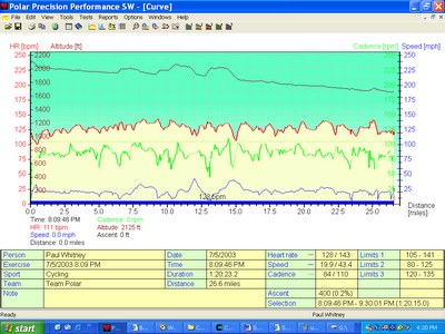 Figure 5: The last leg. Tending downhill. Had the wind. Got the HR up to a pushing-level.
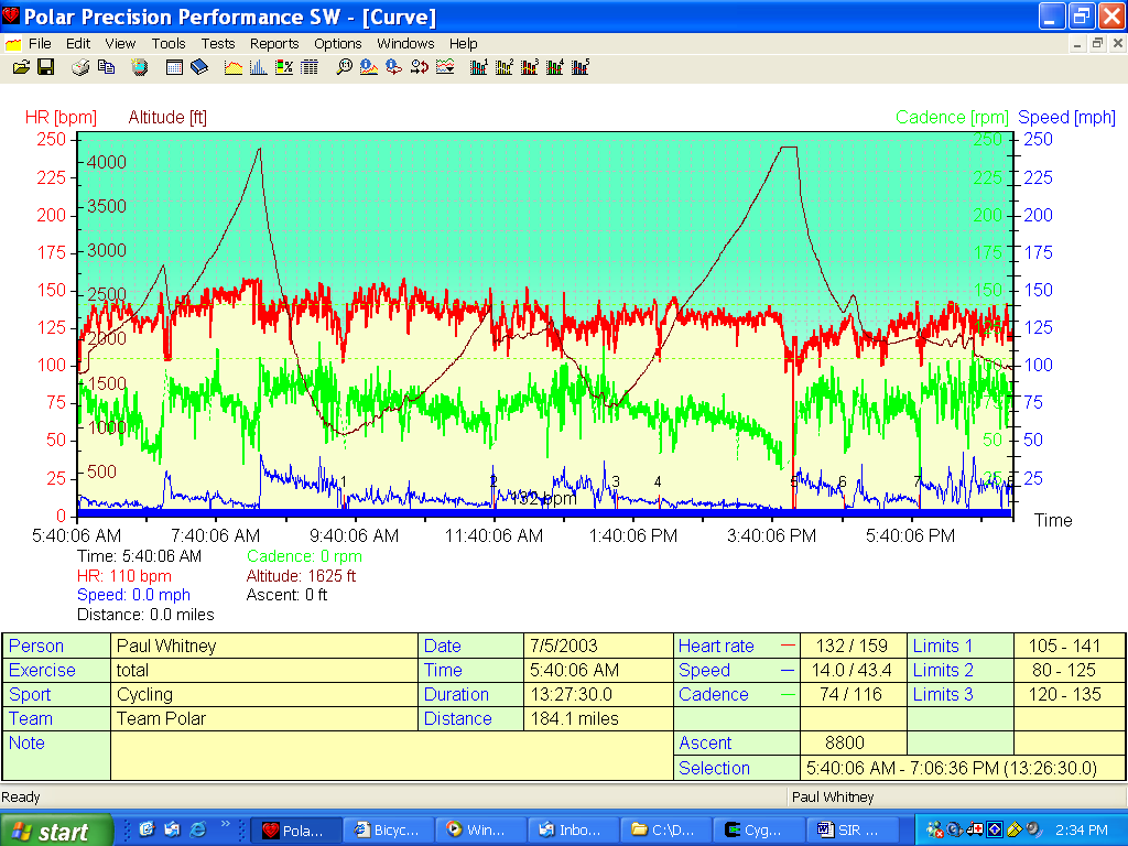
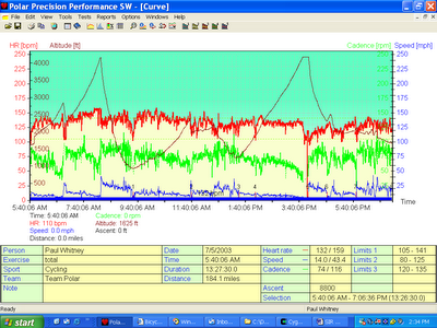 Figure 6: Overall ride summary. The big spikes are Blewett pass (both ways). That’s a pretty high average heart rate for me over that duration. Note: the time axis is not accurate, as it doesn’t incorporate stops and the missing hour.